Category Archives: State Parks

Hot Springs National Park

When I realized I needed to meet a friend from Dallas in New Orleans on Easter weekend, I naturally started to think of how I could extend the visit into a bigger road trip. Checking Hot Springs National Park off the list seemed like an obvious choice, especially since my original plans to visit the park almost five years ago were thwarted when snow in Dallas resulted in a canceled business trip.*

As the park ranger was quick to inform us, by one standard, Hot Springs is the oldest national park because it was set aside as a special reservation in 1832 by President Andrew Jackson (he of the $20 bill—for now). It became an official national park in 1921. At 5,550 acres, it is the smallest park in the system (which surprised me, as I would have guessed Congaree, but that park is almost five times the size of Hot Springs), followed by American Samoa and the Virgin Islands at approximately 10,000 and 15,000 acres respectively.

The heart of the park is Bathhouse Row on Central Avenue but it spills over into mountains on each side, the appropriately named West Mountain to the southwest, and Hot Springs Mountain and North Mountain to the northeast. The forty-seven mineral water springs flow down from Hot Springs Mountain and, since the mid-nineteenth century, have been diverted into public bathhouses and town fountains. The water is odorless and tasteless. (Side note: Unfortunately the weather was rather grey while we were there so I don’t have any great pictures of the town.)

The Arlington Hotel and Bathhouse Row. Photo by the National Park Service.

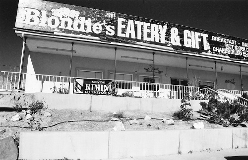
The first European to visit the Hot Springs area was Hernando de Soto in 1541, but the heyday of the park was in the 1920s and 1930s, when the likes of Al Capone and Lucky Luciano came to “take the waters” and baseball players came for spring training. The casinos were shut down in the late 1960s and the town seems to have been struggling to find its footing ever since. We were there on a “race weekend” so it was fairly crowded; however, the pedicurist at the spa told me that their business only really picks up during Spring Break and in the summer. In any case, the town/park has a very out-of-time feel.

Looking down from the trailhead on Hot Springs Mountain.
Looking down from the trail head on Hot Springs Mountain.

On Bathhouse Row, you can tour the beautiful Fordyce Bathhouse, which serves as the national park’s Visitor Center, enjoy local brews (including root beer!) made with mineral water at the Superior Bathhouse, and receive spa treatments or have a traditional bath experience at Buckstaff Bathhouse. There are also a number of cute boutiques along Central Avenue.

The Colonial Candy Corner had these unique sour jellied candies that I couldn't get enough of.
The Colonial Candy Corner had these unique sour jellied candies that I couldn’t get enough of.

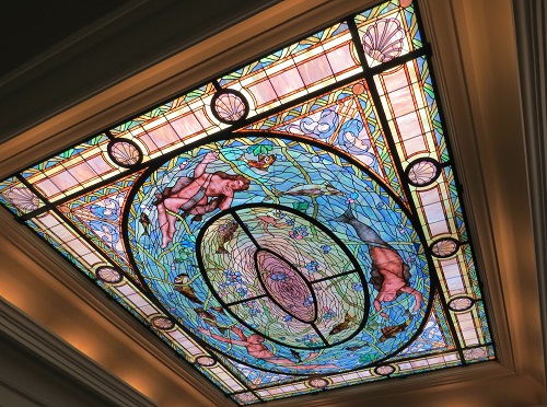
Dominating Central Avenue is the Arlington Hotel, which opened on New Year’s Eve in 1924. It is still the largest hotel in the state and some rooms even have mineral water piped directly into their bathtubs. Unfortunately, while you can’t beat the location of the Arlington (our room looked out over both the park and Bathhouse Row), its old world glamour has been allowed to get somewhat run down. However, it is conveniently located to both the Pancake Shop and the Colonial Pancake & Waffle House, both of which were excellent breakfast places. They do get quite crowded though so go as early as you can.

The other memorable food spot, McClard’s BBQ, was well out of the park area. I enjoyed the ribs, and the coleslaw was great, but I expected more from Bill Clinton’s favorite barbecue joint. Note: We didn’t have tamales, which is apparently a thing at barbecue places throughout the Mississippi Delta. Who knew?

The first of many barbecue joints along the way and the best slaw of the trip.

Hot Springs_McClards 02

As for things to do in the park (besides spa treatments), I highly recommend taking a ranger tour of the Fordyce. We had a fantastic guide—her great aunt had worked in the bathhouses and she was full of stories from interviews she had done with former workers. The story of these (mostly) black workers would make an interesting study all on its own, but combined with the intriguing guests, the history is truly fascinating. Even if you don’t have time for a tour, I would still recommend the building itself. All three floors are beautiful.

Close-up of a window in the women's steam room in the Fordyce bathhouse.
Close-up of a window in the women’s steam room in the Fordyce bathhouse.
The ceiling of the men's changing area in the Fordyce bathhouse.
The ceiling of the men’s changing area in the Fordyce bathhouse.
The music room on the third floor of the Fordyce bathhouse.

Above the bathhouses and the Arlington Hotel are Hot Springs Mountain and North Mountain. While you can drive up to the observation tower at the top, you can also roam over the mountains on a series of short trails climbing up from the Grand Promenade. We did the outer loop, consisting of climbing the Dead Chief Trail to the right (1.4 miles), which then joined the Gulpha Gorge Trail for a bit, eventually connecting to the Goat Rock Trail (1.1 miles). After climbing to the North Mountain Overlook (the view is worth the short climb), we returned via the Upper Dogwood Trail (1 mile). Except for the beginning, which was fairly steep, it was an easy ramble through the woods.

Fun with fungi on the forest trails of Hot Springs Mountain.

Outside of the national park proper, but still in Hot Springs, is Garvan Woodland Gardens. These gardens, donated by Verna Garvan to the University of Arkansas, cover over two hundred acres. We happened to hit right at the peak of the Tulip Extravaganza and I can tell you the name is no joke—apparently there were almost 150,000 tulips. There were also many daffodils still to be seen on the Three Sisters of Amity Daffodil Hill as well as beautiful Japanese magnolia and dogwood trees in the Garden of the Pine Wind. And, remarkable at any time of year, the fare at the on-site eatery—the Chipmunk Café—was quite tasty.

The Bridge of the Full Moon and the koi pond in the Garden of the Pine Wind.
What I think is a Japanese magnolia in the Garden of the Pine Wind.
Cherry? Dogwood? (Yeah, I'm not good with trees) and daffodils abound at Garvan.
Cherry? Dogwood? (Yeah, I’m not good with trees) and daffodils abound at Garvan.
The appropriately named Tulip Extravaganza: Tulips upon tulips upon tulips.
So many tulips... These deep pink beauties were my favorites.
So many tulips… These deep pink beauties were my favorites.

Finally, about thirty minutes from Hot Springs is Lake Ouachita State Park, located within Ouachita National Forest. Here we took the Caddo Bend Trail, a four-mile trail that loops around the Point 50 Overlook peninsula. This trail was nothing spectacular, but the lake is very pretty so it makes for a nice walk. It climbed a bit more than we anticipated, but didn’t take the close to the three hours that the trail marker indicated. All in all, the lake was a lovely surprise after being rather disappointed by our trip up “scenic” byway Highway 7.

The serene Lake Ouachita from the Point 50 Overlook on the Caddo Bend Trail.

Side trip alert: While the focus of our time in Arkansas was Hot Springs, I wish we had had time to see the northwest corner of the state, which looks to be absolutely beautiful. However, one stop we did make on our way to Memphis was Little Rock’s Central High School. As my most recent editorial project was a U.S. history textbook, I was eager to see this infamous civil rights location. The school is still functioning as a high school, but the nearby Visitor Center documents the trials and tribulations of the Little Rock Nine in their efforts to integrate the school in the late 1950s. Kudos to the National Park Service as this is one of the best museum displays I’ve seen—you can glean a brief (but comprehensive) overview of the 1957 events and the civil rights movement from the timeline panels, or linger and watch the numerous video clips containing news footage and personal interviews. Many of the multimedia stands are located in front of plate-glass windows providing a view of the gas station and school across the way. It really makes history come alive.

“If you just don’t say anything, you’re part of the problem and not part of the solution. If all the other teenagers had been like the Little Rock Nine, they could have changed the situation.”—Minnijean Brown Trickey

Little Rock Central High School, site of the 1957 Desegregation Crisis.

Entry to both Hot Springs National Park and the Little Rock Central High School National Historic Site is free.


*Note: While Hot Springs is closer to both Little Rock (1 hour) and Memphis (3 hours), the drive from Dallas is quite reasonable (4.5 hours), if boring. But Dallas worked for me logistically and flights there were cheaper than other options.

Road Trip: The Grand Circle

Thanks to all of you who joined me in revisiting my trip around the Grand Circle in honor of National Parks Week. I’d like to give a special shout-out to my new followers: Welcome! You have inspired me to continue on a more regular schedule here. Keep an eye out for upcoming posts on some of my favorite national parks, including Grand Teton and Yosemite, as well as road trips in the Carolina Low Country, the Scottish Highlands, and West Texas.

When last we left the Grand Circle, I was in Monument Valley. I’m afraid there’s not much more to report after that. The drive from Monument Valley back to Las Vegas via the Grand Canyon can only be described as a whirlwind. With four to five hours of solitary driving each day, there wasn’t much time for sightseeing. I arrived fairly late at the Grand Canyon, and then had to leave very early in the morning. Luckily, I did manage to get a cabin at the Bright Angel Lodge, which meant that I was right on the rim of the canyon and could sneak in a sunrise hike partway down the Bright Angel Trail. It was very quiet at that hour but I was so intent on setting up my tripod for some shots that I didn’t notice that a bighorn sheep had come up behind me and was about to knock my tripod over the cliff! An incredible moment, sadly not captured on film.

Bighorn sheep sneak up on you when you least expect it.

Frankly, I have to say that the Grand Canyon was somewhat of a disappointment after all I’d seen on this trip. Of course, the scale is amazing, but it’s not nearly as pretty as some of the other parks and is a far less intimate experience. But perhaps that is only because I was rushed. This was the second of two abbreviated trips I’ve made to the Grand Canyon and one day I would really like to spend more time there, especially if it involves rafting in the canyon itself and/or a stay at Phantom Ranch.

Mule train down to Phantom Ranch

Of course, I always want more time. While I took ten days for this trip, and it’s very doable in that amount of time, I would suggest a full two weeks to complete the full circle, perhaps adding a few more days if you want to spend any time in Vegas itself. If I had to do it all over again, I would add another night at the Boulder Mountain Lodge, one in Moab in order to properly visit both Arches and Canyonlands, and one at the Grand Canyon.

This is not really because I felt I gave any of these parks short shrift, but rather because the beauty of the Grand Circle is that even outside the main attractions, there are many interesting things to see and do along the way and it’s nice to be able to stop and smell the desert roses. Side trips abound, such as Dead Horse Point State Park, which is most familiar as the scene of Thelma & Louise’s final send-off, and Newspaper Rock, a sandstone wall covered with 1500-year-old petroglyphs (just there by the side of the road on the way to the Needles district of Canyonlands).

Newspaper Rock in black and white (and read all over)

Not to mention the many picturesque diners along the route. I mean, don’t you want to be able to say you’ve tried a “ho-made” pie? Or any pie, really. I can still taste the enormous slice of banana cream pie I had at the Pine Country Restaurant in Williams, Arizona. That thing was a meal unto itself.

The Thunderbird Restaurant, Mount Carmel, Utah
Blondie's in Hanksville, Utah, or, as we called it, "The Scary Diner"
Blondie’s in Hanksville, Utah, or, as we called it, “The Scary Diner”

To read the complete Grand Circle series, click below:
Zion National Park
Bryce Canyon National Park
Capitol Reef National Park
Arches National Park
Monument Valley


*Note: This trip was back in the days of my much-loved Pentax K1000. As such, most of the pictures in this Grand Circle series are scans of my printed photos.

Capitol Reef National Park

It may seem that Capitol Reef is the neglected step-child of the five national parks in southern Utah, and I suppose in many ways it is. In fact, I’m not sure I had even heard of it before I started researching this Grand Circle trip, which was well before I began my parks project. However, one of the reasons we decided to include it was to stay at the Boulder Mountain Lodge in Boulder, Utah (B on the map above), one of ten great budget lodges on a list I had from my favorite travel magazine ever, Budget Travel, which is sadly no longer in print but still exists online. Not only do I highly recommend the lodge, and especially the restaurant, the Hell’s Backbone Grill, but this part of the trip proved to be a lovely interlude between the twin juggernauts of Zion-Bryce and Arches-Canyonlands. In short, there are a number of reasons to travel the almost 300 miles between Bryce Canyon (A) and Arches National Park (E).

While we spent two delightful nights at the Boulder Mountain Lodge, which included chatting politics with the chef-owners of the restaurant (it was October 2008 after all) and enjoying the fruits of their on-site organic farm, I think we all wished we had factored in more time here. Boulder, Utah is just under two hours from Bryce Canyon on Highway 12, or Scenic Byway 12, a gorgeous road through the heart of the biggest national park in Utah that is not a national park, Grand Staircase-Escalante National Monument. At nearly two million acres, Grand Staircase is enormous, and, yes, for this reason it is stupid that it’s called a “monument” but let’s just all hope that one day it grows up to be a real park. [Side note: There is a long history of presidents using the Antiquities Act of 1906 to immediately protect lands that are later granted national park status.] While Grand Staircase is more of a backcountry park, there is a relatively easy 5.5-mile round-trip hike that takes you out to Lower Calf Creek Falls, a lovely spot for a picnic. There are sandstone cliffs, pictographs, and various flora and fauna to keep you entertained along the way.

Staircase 01

Staircase 02

Staircase 03

Staircase 04

A fun drive to take, if your car can handle rougher terrain, is the Burr Trail Road, which starts in Boulder, winds through Long Canyon, and eventually ends up at a side entrance to Capitol Reef National Park. While you probably don’t want to go that far, it’s a beautiful drive that eventually opens up to an excellent view of the Waterpocket Fold, the 100-mile-long wrinkle in the earth that is Capitol Reef. The park itself is best entered from Highway 24.

The Waterpocket Fold is a must-see for any geology fans. I highly recommend buying the recording at the Capitol Reef Visitor Center (C), which provides you with a guided audio tour of the geological features along the 25-mile Scenic Drive. Seeing the various rock strata on full display is actually far cooler than I thought it would be.

NP_Capitol Reef_01

NP_Capitol Reef_02

In addition to looking at rocks, you can also walk among them. With proper planning, you could easily do the entire Grand Wash Trail, which runs from the Scenic Drive out to Highway 24, or simply walk the Grand Wash Canyon part of it and retrace your steps back to the Scenic Drive. At the end of the Scenic Drive is another short walk to some petroglyphs. During harvest season, you can “pick-your-own” in the Fruita orchards, left by Mormon settlers and now maintained by the National Park Service.

Entering Grand Wash Canyon and feeling very small. Note: Always check for flash flood warnings.
I found the "desert varnish" on the walls of Grand Wash Canyon to be extremely beautiful.
I found the “desert varnish” on the walls of Grand Wash Canyon to be extremely beautiful.

Last, but not least, this route contains a little-known gem that was recommended to us to break up the 150-mile trip from Capitol Reef to Moab, which is a long stretch of fairly dull landscape. Goblin Valley State Park has a bit more notoriety now as the scene of a viral video showing Boy Scout leaders knocking over one of its 20-million-year-old hoodoos.

SP_Goblin 00

This state park is hidden in the middle of nowhere, twelve miles off Highway 24 (D). It is a small valley of crazy, random, mushroom-like stones, similar to the hoodoos of Bryce Canyon, but much smoother. I felt as if we had wandered onto the cheap set of an early Star Trek episode. One thing was for sure, the kids we saw were absolutely delighted to be running around and among all these bizarre shapes. I even went black & white for the occasion.*

SP_Goblin 01

SP_Goblin 03

SP_Goblin 02

Entry to Capitol Reef National Park is $5 per car for seven days. The day-use fee at Goblin Valley State Park is $8 per car.


*Note: This trip was back in the days of my much-loved Pentax K1000. As such, most of the pictures in this Grand Circle series are scans of my printed photos, including these black & white images.

Redwood National Park

Having just traveled on the Redwood Highway (aka US 101) this past weekend, I realized that a post on Redwood National Park was long overdue. I avoided writing about this park immediately after my July road trip because it was such an odd experience for me. Walking through the trees is itself intensely spiritual, but, for me, driving through the park became almost Proustian as my childhood flashed before me and I realized with a shock that I had been there before.

Lost in the monarchs of the mists of time

“A fool sees not the same tree that a wise man sees.”
—William Blake

I had known that on a long-ago trip to California with my family we had driven through a redwood tree, but I couldn’t remember where, and I was sure we hadn’t gone that far north. But, as I saw kitschy roadside attraction after kitschy roadside attraction (the Trees of Mystery, Paul Bunyan and Babe the Blue Ox, the One Log House), it all came flooding back.

It is truly a wondrous place.

Is this the next concept in the Planet of the Apes franchise?
Stout Grove in Jedediah Smith Redwoods State Park

Redwood National Park is actually made up of three state parks with additional land added on, totaling over 130,000 acres, but in no real pattern. So, one weaves in and out of the park as one drives along. It is probably for this reason that the National Park Service does not charge its usual vehicle fee. At the Kuchel Visitor Center near Orick, the ranger told me to avoid Lady Bird Johnson Grove (generally the most crowded spot since every guidebook mentions it) and said I would see just as many old growth trees by taking my planned route on the Newton B. Drury Scenic Parkway through Prairie Creek Redwoods State Park and the Howland Hill Road in the Jedediah Smith Redwoods State Park.

The Newton B. Drury Scenic Parkway is a brief detour off of Hwy 101 that takes you through Elk Prairie Meadow and right by the aptly named “Big Tree Wayside” stop. Although one sees them elsewhere, this is probably your best chance of spotting elk.

A Roosevelt elk in Prairie Creek State Park
At first I thought there was only one elk in this field and that these were branches!

Elk were not the only wildlife I saw. In an incredible, but ultimately sad, turn of events, a gray whale and her baby had swum up the Klamath River a few weeks before my arrival and had taken up residency under the Klamath Bridge, where hoards of tourists would flock from one side to the other as the whale swam beneath it. The baby was successfully driven out to sea, but the mother eventually beached herself and died weeks later.

Gray whale in the Klamath River

Howland Hill Road, at the northern-most end of the park just south of the Oregon border, is a bit harder to find but is absolutely worth the trouble. If you follow the entire road, past Stout Grove and out to Route 199, you can loop around and rejoin US 101 without doubling back. The drive is an incredible experience with trees immediately on either side looming over the (often) one-lane road.

Howland Hill Road in Jedediah Smith Redwoods State Park
Stout Grove, off Howland Hill Road

If you want to get a taste of the redwoods and can’t make it all the way up north, you can drive the Avenue of the Giants, a 30-mile stretch of road that parallels Highway 101 as it winds its way through Humboldt Redwoods State Park. The southern entrance of this route is at Phillipsville and the northern at Pepperwood, just 200 miles or so north of San Francisco. If you want to walk among the trees for a bit, I recommend the Loop Trail in the Founders Grove. Even though Return of the Jedi was actually filmed on private land just north of the National Park, this trail was where I most felt like I was on that movie set.

Can't you just see an Ewok climbing over this at any moment?


Mission Impossible: La Purísima

Misión la Purísima Concepción de María Santísima is a short detour off of Highway 101 on the outskirts of Lompoc, CA. Founded in 1787, La Purísima is the eleventh of the 21 Franciscan missions in Alta California. Originally in Lompoc proper, it was moved to its present location outside the city and on El Camino Real in 1812 after an earthquake destroyed the original church and vestry.

This is the most complete restoration project on the entire Mission Trail, with work beginning in the 1930s under the National Park Service and the Civilian Conservation Corps. The buildings and grounds are extensive with furnishings, tools, and even animal breeds (Churro sheep, goats, longhorn cattle, burros, etc.) from the Spanish period. More than any other mission I’ve visited, La Purísima really gives one the sense of what life was like back then. And, if you like the outdoors, there are twenty-five miles of hiking, biking, and equestrian trails to explore.

Because this is also a California State Park (but not one of the many closed due to the inherent cheapness of the California taxpayer), there is a Visitor Centor and Exhibit Hall to get you oriented.

Doesn’t this soldier seem happy to be working at the mission?
I’m sure the sheep and goats are happy too.

Monks were green even way back when: The fountain above was used for drinking, with run-off piped to the lavanderia, whose run-off went to the cistern where soap settled at the bottom and the remaining water was used in the gardens.

Over 1000 people were involved in weaving activities.
The monks apparently had a thing for EVOO.
Confessional or amateur puppet theater? You be the judge.

Is it a sin to covet a monk’s bookshelves? If so, color me guilty.